News | 2026/03
Canary Islands Bracing for Severe Storm Theresa: Travel Disruptions Expected

Travelers in the Canary Islands are advised to take precautions as Storm Theresa approaches, bringing torrential rain, 5-meter waves, and high-speed winds to the archipelago.
While much of mainland Europe continues to enjoy stable high-pressure systems and clear skies, the Canary Islands are currently facing a completely different reality. The popular tourist archipelago is actively bracing for the impact of Storm Theresa, a severe weather event threatening to bring torrential rains, massive coastal swells, and gale-force winds over the coming days.
According to meteorologist Dr. Karsten Brandt, who recently spoke with BILD, the current weather situation is the result of an “omega block” pattern.
“This setup means the Canary Islands will experience localized, heavy rainfall that will last for several days,” Dr. Brandt explained. “Meanwhile, a high-pressure system is maintaining beautiful, stable weather over countries like Germany.”
Widespread Closures and Safety Measures
The impending storm has already triggered sweeping safety protocols, meaning visitors expecting a sunny beach vacation might find their itineraries heavily altered. In anticipation of the severe weather, local authorities preemptively closed all schools and kindergartens across Tenerife, La Palma, La Gomera, and El Hierro. As the storm system intensifies today, these mandatory closures have been expanded across the entirety of the Canary Islands.
Government officials have also urged residents and workers to transition to remote work wherever possible to keep the roads clear and minimize risk.
What Travelers Need to Know
For tourists currently on the islands, the next few days will likely be highly disrupted. Aemet, Spain’s national meteorological service, has issued urgent warnings across the region.
Here is what is currently expected:
- Gale-Force Winds: High-altitude regions are preparing for fierce wind gusts that could reach up to 90 km/h (56 mph).
- Extreme Rainfall: Meteorologists warn that some localized areas could receive precipitation equivalent to their normal annual rainfall in just a matter of days.
- Dangerous Coastal Conditions: The Atlantic is expected to churn out massive waves reaching up to five meters (16 feet) high, making beaches completely off-limits.
- Mountain Snow: Curiously, the storm’s intensity and associated temperature drops mean that locations situated above 1,800 meters might even experience unexpected snowfall.
Travelers relying on island-hopping ferries or scheduled flights should contact their transport providers immediately. With the storm intensifying, local authorities anticipate severe transport restrictions, with widespread flight cancellations and ferries remaining securely docked until conditions improve.
More news

Canary Islands Bracing for Severe Storm Theresa: Travel Disruptions Expected
Travelers in the Canary Islands are advised to take precautions as Storm Theresa approaches, bringing torrential rain, 5-meter waves, and high-speed winds to the archipelago.

The Most Beautiful Place on Earth in 2026 Has Been Revealed
Time Out magazine has crowned a dramatic, compact mountain range in northern Spain as the world's most beautiful destination for 2026.

Madrid crowned Europe's best New Year's Eve destination by travel expert
Travel writer Dana Camilleri Clark names Madrid the ultimate European city for New Year's Eve celebrations, with unique traditions and legendary nightlife.
Book top activities
Top tours for you
Latest articles
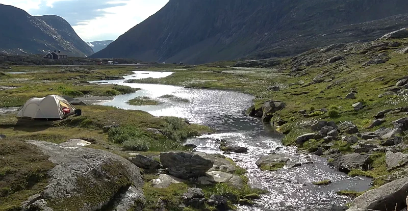
Wild Camping in the Norwegian Mountains: A Scenic Road Trip
Join a breathtaking road trip through the lush green fjords and majestic mountains of Norway. Experience the thrill of wild camping and a luxurious stay in the wilderness.

Top 10 Magical Places to Visit in Cappadocia, Turkey
Discover the magic of Cappadocia, Turkey, a historical region with unique rock formations, cave churches, and unforgettable hot air balloon rides at sunrise.
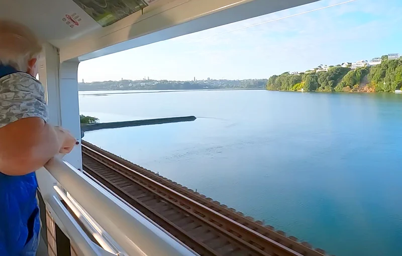
Crossing the North Island: The Northern Explorer Train from Auckland to Wellington
Embark on an unforgettable 12-hour journey across New Zealand's North Island aboard the Northern Explorer. From the bustling city of Auckland to the capital Wellington, witness dramatic volcanic landscapes, deep canyons, and engineering marvels.
Book your next trip